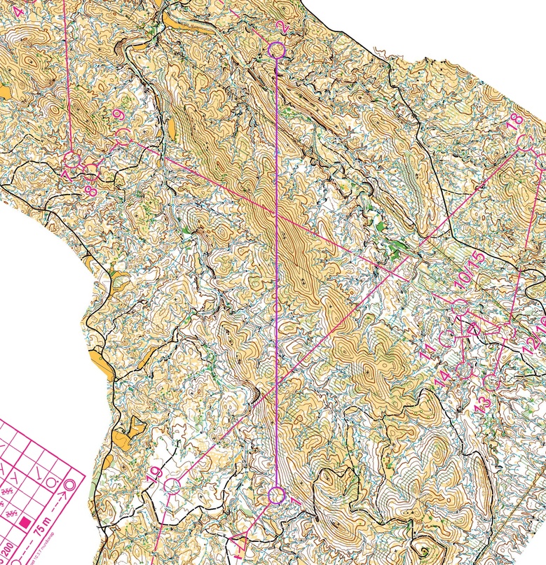
This year traditional competitions Costa Cálida (Spain) were organized at famous En Coto de Las Maravillas, where the World Cup 2014 took place.
Organizers did a good job and prepared courses of high technical level, and the most interesting here are the long legs, which we are going to use to do some analysis and learn how actually the sportsman can work with a long leg to success in their choice.
Indeed, the long legs here were a great success for the organizers. Let’s take a closer look at the second leg of the men’s race. It’s very similar for women, but I like the men’s version better as it’s slightly offset to the right, giving a little more flexibility to the right side.
Imagine, after the first “shocking” short leg, you immediately have to make a fateful decision – what to prefer at the second checkpoint. A mistake with this option in this area can cost you several minutes. And a mistake in implementing your own option can cost even more. Go ahead! How are we running?
Before you read the article, try to practice. Choose the option you would have taken! Then read and check if runners chose the same!
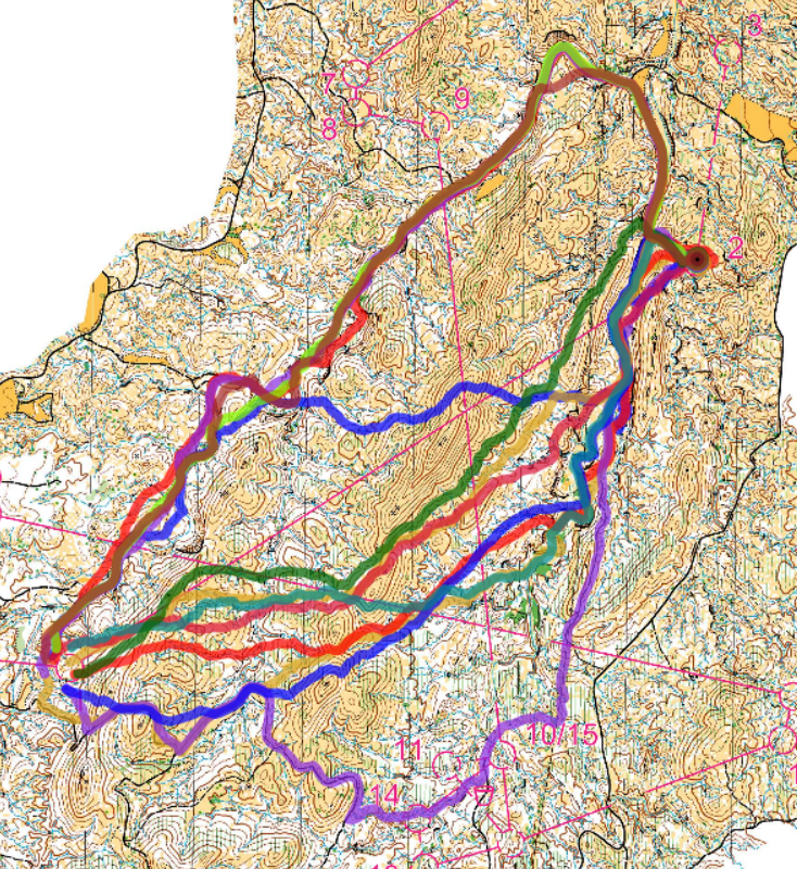
And here are the main versions of the Costa Cálida participants. Amazing variety, and these are only those participants who carried a GPS or downloaded their tracks after the finish. Who is right? And how to make a decision if your eyes are full of brown, black, green and even blue?
As we know, not every option suits everyone, so everyone decides where exactly is MY option that I can implement in the best way and therefore show my best result.
Where do we start choosing an option on this leg?
From the inspection of the entire leg. What to look at? First of all, we try to see the global picture of the route, to notice the difficult obstacles that stand on the way. Here we have mountains that are quite decent in height, and this is how they are located (I highlight these forms with bright colors):
The scale is 5m, and this is real 5m!, so closely drawn 3-5-7 or more contour lines will be more than a serious obstacle.
First of all, we see two large ridges diagonally crossing the red line. It is also important to note that there are three more long and high hills, crossing those will definitely slow down the speed.
When examining such mountains, we also pay attention to the fact that in some places it is still possible to cross them. The ridges have saddles (marked with green):
Crossing the main ridge along the green section means saving a few contours.
But not all saddles have a comfortable approach to them, for example, the saddle at the first ridge is located above a high rocky cliff, which makes it difficult to reach it with a minimum climb. There you still have to climb at least up to the thickened horizontal, and this is one of the steepest slopes. So we can’t consider it as a very comfortable saddle to cross the ridge.
And now, let’s see what trails, roads or simply flat places and hollows that are convenient for running are available on our leg:
To make them easier to see, I highlight them with color. First of all, there are good roads around the hills.
The right and left alternatives have a partial road option, but only the left one bypasses the entire ridge.
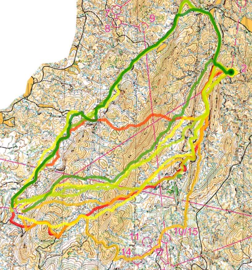
Then, flat sections with which you can move from one road to another. For example, at this terrain, the bottoms of many of the main ravines have a flat, wide space, along which it is convenient and quite easy to run.
This view also helps to see that it is most convenient to approach the control point from the main fork in the ravines in order to avoid crossing an extra ridge in the last 200m before the control point. Entering from the northern path is also possible, although it involves a long detour and a so-so section before reaching the long road.
From everything you have seen, you can form 4 basic alternatives:
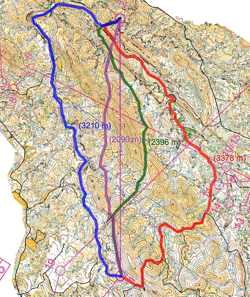
Three right-hand alternatives cross two ridges. The rightmost one does this along the road, but climbs almost to the very top. Also, the right alternative after the road is forced to go through many similar ravines before finding an exit to the road. There are many different sub-options for how exactly to get to the fork in the main ravines, and the participant will have to decide for himself exactly how, because there is a risk of getting stuck in thorns, hanging on a rock or getting lost in the endless turns of the ravines.
Considering that the approach to the control point is shifted to the left, the left option no longer seems to be such a bypass. It is only 170m shorter than the one on the right, but it goes around all the ridges.
The lilac option, one of the shortest, saves more than 1 km of length, but crosses all the ridges, gaining more than enough extra contours. Rocky soil, hard tufts of grass up to the middle of the thigh and thorny bushes up to the waist – this is a summary of the runnability of this area. The participants had an idea about this from the previous day of Middle distance race, but we can find out thanks to some youtube video. Therefore this option is in no way considered a mistake! Especially if you are in excellent physical shape! Many participants chose this option.
The left alternative goes around all the mountains, and this is obviously an advantage. On the downside, the first half of the leg will still have to be worked out well: the bottom of the ravine is winding, and you need to work hard to cut off the extra corners properly. Although in general, there is a good runnability of white forest there.
Who won this long leg?
Of the tracks uploaded to the Internet, Quentin Andreux (OK Denseln) shows the best time running on the left option. The best split, Emil Svensk (Stora Tuna), also took the same left option, even though we don´t have his track here. A well executed direct variation lost in just 1:12 (Ruslan Glebov)!
Have you changed your choice of option after reading this analysis? What micro-adjustments can be made to the right-hand options to make them faster?

Leave a comment